Satellite Missions

Différence de phénologie des chênes.

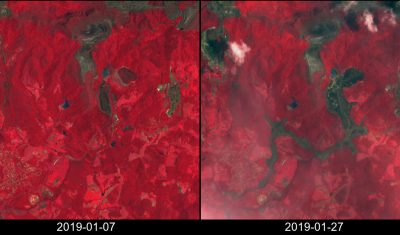
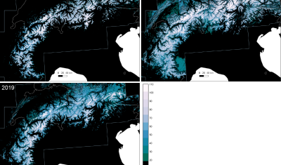
4 thèses en cours à Toulouse pour étudier les forêts tempérées par télédétection

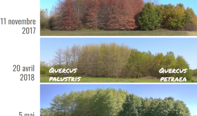
Le pôle toulousain de recherche publique en télédétection est surtout connu sur la thématique forestière grâce à la mission BIOMASS, qui sera lancée vers 2021 et qui est portée par le CESBio, mais qui concerne surtout les forêts tropicales. L’objectif de cet article est de présenter les travaux en cours sur les forêts tempérées, dans […]

30.01.2019

S1Tiling : ortho-rectification à la demande des données Sentinel-1 sur la grille Sentinel-2

=>​ Sentinel-1 est actuellement le seul système à fournir des images SAR régulièrement sur toutes les terres de la planète. L’accès à ces séries temporelles d’images ouvre un champ d’application hors du commun. Afin de répondre aux besoins d’un grand nombre d’utilisateurs, dont les nôtres, nous avons créé une chaîne de traitement automatique permettant de […]

Sentinel-2 + OpenStreetMap = ♡

You may have heard about the tailings dam collapse at Feijão mine in Brumadinho, Brazil. The disaster occurred two days ago on Jan 25 and at least 58 people were found dead, while 300 are still missing. A Sentinel-2 acquisition was planned for today, therefore tonight I checked the EO Browser to see if the […]

27.01.2019

Near-real time analysis of the 2018-2019 snow season in the Pyrenees and the Alps from satellite data

Here in southwest France ski lovers did not really enjoy the beginning of the snow season… But how does it compare to the previous years? Using Sentinel-2 and Landsat-8 data, we computed the snow cover duration since September 01 until January 20 for the past three snow seasons in the Alps and Pyrenees.

25.01.2019

Anak Krakatau before and after the December 2018 eruption

Anak Krakatau (Indonesia) erupted on 22 December 2018. During the eruption the collapse of the volcano summit triggered a tsunami in Sunda Strait causing a death toll of 437. The first post-event clear-sky image was finally acquired by Sentinel-2 today on 13 Jan 2019 (after 10 cloudy acquisitions). Here is an image comparison of the […]

13.01.2019

Improvement of water vapour retrieval in MAJA

Similarly to the aerosol retrieval, the retrieval of water vapour in MAJA atmospheric correction has also been improved, thanks to the work of Elsa Bourgeois (Cap Gemini) and Camille Desjardins (CNES). An accurate estimation of water vapour is not necessary to perform an accurate atmospheric correction, because water vapour absorption in most of Sentinel-2 bands […]

20.12.2018

MAJA 3.1.2 with CAMS option finally validated

We had announced quite a long time ago the coming availability of MAJA 3.1 to correct for the atmospheric effects on Sentinel-2, Landsat 8 or Venµs satellites. This version brings a significant improvement in the estimation of Aerosol Optical Thickness, thanks to the use of Copernicus Atmosphere Monitoring Service (CAMS) data to constrain the aerosol […]

Two billion pixels to check your next ski destination

More exactly: two maps of 934’343’100 pixels! We [1] have processed 6205 Sentinel-2 images and 593 Landsat-8 images to compute the annual snow cover duration in the Alps and the Pyrenees at 20 m resolution for hydrological years 2016-2017 and 2017-2018. The snow cover duration (or snow persistence) is defined as the total number of […]

12.12.2018

Theia just selected a new production zone for Sentinel-2 L2A in Sahel

=> The Level 2A data production with MAJA processor, by MUSCATE processing center is now fast and efficient. Some margins have been found to add new zones to our production. (The zones already processed are displayed here). French public institutes of labs that would need new zones can tell us their needs, we should still […]

19.11.2018

Rechercher