Non classé

THEIA releases Sentinel-2 L2A time series over several regions of Brazil

Theia has added seven new sites in Brazil, for which Sentinel-2 L2A are produced and distributed, starting in December 2016.  These sites will be processed in near real time from now on. Data are produced by the MUSCATE system at CNES, using CNES-DLR MAJA processor. The products can be freely downloaded from https://theia.cnes.fr. These sites were […]

11.07.2017

Issue with Firefox 53 on Theia distribution server

We recently figured out that the Theia distribution server is not fully compatible with the most recent version of Firefox (V53), and that the authentication fails, preventing from downloading products with that version. The teams are working to solve this, but meanwhile, please wait before updating your firefox browser. Nous nous sommes récemment aperçus que […]

11.05.2017

Un nouvel algorithme de détection des nuages pour la Bretagne

Ce nouvel algorithme baptisé MACCROW (Multitemporal Atmospheric Correction and Cloud Retrieval Of Western-France) a été développé par l’équipe MACCS pour résoudre le cas spécifique des régions à forte nébulosité. Comme nous l’a expliqué Olivier Hagolle, chercheur au Cesbio, « l’algorithme se base sur le fait que la reflectance au sommet de l’atmosphère chute brutalement lorsque le […]

01.04.2017

S2 Tile Viewer/ Voir les tuiles Sentinel-2

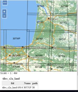
Here is a map of all the Sentinel-2 tiles .that contain some land (some islands might have been missed). If you zoom enough, the tile number will be displayed on the map. The tool was developed by Michel Le Page, using Geoserver and openlayers. To find it next time, use the Sentinel-2 menu.  Voici une […]

05.02.2017

La lettre d’informations n°22 du CESBIO est sortie

La lettre trimestrielle d’informations du CESBIO vient de sortir, avec au menu, des estimations de  température ou de rugosité des sols, beaucoup de neige, de l’humidité, des estimations de biomasse et de rendement, des données Sentinel-2 mises à disposition, des détections de cultures, une médaille d’honneur, et des annonces de formations, de thèses, et la […]

14.10.2016

Irrigated crop maps for a better water management in agriculture

=>In a previous post, i have briefly presented: To classify irrigated farmland, within the growing period and at the scale of a territory, we focused on the use of optical remote sensing images. In the lines below, I will introduce the work to generate maps of irrigated crops usin Landsat-8 time series level 2A made […]

06.10.2016

Formosat-2 de-commissionned

=> It is with a deep nostalgia that I learned that Formosat-2 has just been decommissionned, after some of its components broke down after 12 years of acquisitions (nominal life extended by 8 years !). When the satellite was launched, we were searching for data sets that would allow us simulate the features of VENµS satellite (which […]

31.08.2016

Premier test de Sen2cor V2.2.1 (et comparaison avec MACCS)

=> Deux ou trois jours avant le symposium Living Planet, l’ESA a mis en ligne la nouvelle version de Sen2cor (V2.2.1), le logiciel de correction atmosphérique de Sentinel-2. J’avais déjà publié une comparaison basée sur la version V2.0.6, dans laquelle je concluais que la détection des nuages et des ombres était très mauvaise, mais que c’était […]

22.05.2016

Série temporelle de chats

=> La télédétection satellite optique est un outil formidable pour suivre l’étendue du manteau neigeux en montagne… sauf quand il y a des nuages ! La télédétection radar du manteau neigeux (indifférente aux nuages) n’est pas encore opérationnelle en zone de montagne, notamment en raison du fait que le signal rétro-diffusé par le manteau neigeux […]

11.05.2016

Rechercher