15 000 !
Theia’s Sentinel-2 L2A counter passed the 15 000 threshold on the 26th of May. The joined image shows the zones which are available so far. Recently, two more sites have been added to THEIA’s list of processed sites :
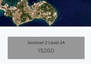
Theia’s Sentinel-2 L2A counter passed the 15 000 threshold on the 26th of May. The joined image shows the zones which are available so far. Recently, two more sites have been added to THEIA’s list of processed sites :

=> The Sentinel-2B satellite was launched in March 2017, and joined his twin brother Sentinel-2A, which was orbiting since June 2015. Both satellites are now succeeding each other above our heads every 5 days. Sentinel-2 system mission is to monitor the evolution of the landscape and especially vegetation, with an observation every fifth day. Very quickly, ESA managed […]

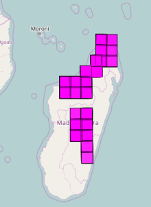
Here are the sites that will be observed by the long awaited French-Israeli satellite Venµs. Venµs will be launched this summer, and three months after launch, all the sites will be observed each second day from a constant viewing angle with 10m resolution and 12 spectral bands. Combined with Sentinel-2 and Landsat 8, a daily […]
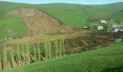
In this post « Landslides in Kyrgyzstan captured by Sentinel-2 » I showed two landslides that I identified as the Kurbu and Ayu landslides, both featured in the AGU landslide blog. However, as pointed out by Isakbek Torgoev, the Kurbu-Tash landslide is located about 5 km farther south than the one I found on the Sentinel-2 image […]

=> On Feb 16 2017, French Astronaut Thomas Pesquet shot this photo from the International Space Station.
OTB version 6_0 is out ! It includes many improvements (including an unsupervised machine learning framework), and adopts a new, more permissive licence : Apache v2.0My colleagues in charge of the Orfeo Toolbox Development (OTB) are organizing the annual user meeting in Toulouse town center : June 7-9 2017. Here is the program : If interested, […]
After a good period with very little production incidents, our Muscate facility has had a tough period, which almost halted the production for one week. Until last week, the Muscate ground segment was running on CNES older cluster, and was just using the new cluster’s bay of disks to store the input and output data. […]
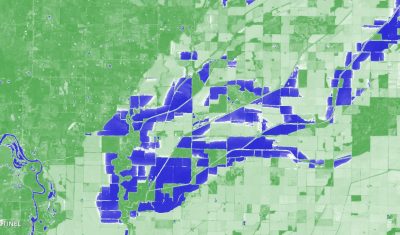
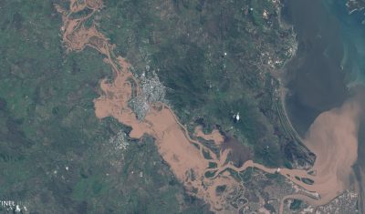
These Sentinel-2 images show the extent of the recent flooding near the border between Arkansas and Missouri on Apr 24, 2017 (36°30’N 90°38’W). The left image is a natural color composite (similar to what our eyes could see if we were in orbit). The right image is a color representation of the Normalized Difference Water […]
The Google Earth Blog spotted the recent Queensland floods in Sentinel-2 imagery. The Sentinels provide systematic coverage of the land areas, which facilitates the detection of changes due to natural hazards. Hence we can compare this Sentinel-2A image with another one that was captured last year during the same season to better highlight the extent […]