In English

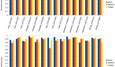
New paper ! An active learning cloud detection tool to generate reference cloud masks for Sentinel-2. Application to the validation of MAJA, Sen2cor and FMask cloud masks

It is not that frequent when the work of a trainee ends up as a peer reviewed publication, but Louis Baetens was a brilliant trainee. In a six months training period at CESBIO, funded by CNES, here is what Louis Baetens did: The publication was just released by remote sensing :Baetens, L.; Desjardins, C.; Hagolle, […]

20.02.2019

Apport des images radar et optiques pour la cartographie des surfaces irriguées

(English version below) Dans le cadre du projet Simult’eau (partenaires : Arvalis, CACG, Chambres d’Agriculture du Tarn et des Hautes-Pyrénées, financement CASDAR) nous avons testé l’apport d’une utilisation combinée des images radar et optiques pour la cartographie des surfaces irriguées (maïs et soja) dans le Sud-Ouest de la France. Les résultats publiés dans Remote Sensing […]

12.02.2019

Release of MAJA 3.2

The version 3.2.2 of MAJA cloud detection and atmospheric correction software has just been released! It brings a lot of improvements. It can be used to process Sentinel-2 data in four different manners that will be described below : Improvements

11.02.2019

S1-Tiling, on demand ortho-rectification of Sentinel-1 images on Sentinel-2 grid

=> Sentinel-1 is currently the only system to provide SAR images regularly on all lands on the planet. Access to these time series of images opens an extraordinary range of applications.In order to meet the needs of a large number of users, including our needs, we have created an automatic processing chain to generate « Analysis […]

30.01.2019

Sentinel-2 + OpenStreetMap = ♡

You may have heard about the tailings dam collapse at Feijão mine in Brumadinho, Brazil. The disaster occurred two days ago on Jan 25 and at least 58 people were found dead, while 300 are still missing. A Sentinel-2 acquisition was planned for today, therefore tonight I checked the EO Browser to see if the […]

27.01.2019

Near-real time analysis of the 2018-2019 snow season in the Pyrenees and the Alps from satellite data

Here in southwest France ski lovers did not really enjoy the beginning of the snow season… But how does it compare to the previous years? Using Sentinel-2 and Landsat-8 data, we computed the snow cover duration since September 01 until January 20 for the past three snow seasons in the Alps and Pyrenees.

25.01.2019

Anak Krakatau before and after the December 2018 eruption

Anak Krakatau (Indonesia) erupted on 22 December 2018. During the eruption the collapse of the volcano summit triggered a tsunami in Sunda Strait causing a death toll of 437. The first post-event clear-sky image was finally acquired by Sentinel-2 today on 13 Jan 2019 (after 10 cloudy acquisitions). Here is an image comparison of the […]

13.01.2019

Improvement of water vapour retrieval in MAJA

Similarly to the aerosol retrieval, the retrieval of water vapour in MAJA atmospheric correction has also been improved, thanks to the work of Elsa Bourgeois (Cap Gemini) and Camille Desjardins (CNES). An accurate estimation of water vapour is not necessary to perform an accurate atmospheric correction, because water vapour absorption in most of Sentinel-2 bands […]

20.12.2018

MAJA 3.1.2 with CAMS option finally validated

We had announced quite a long time ago the coming availability of MAJA 3.1 to correct for the atmospheric effects on Sentinel-2, Landsat 8 or Venµs satellites. This version brings a significant improvement in the estimation of Aerosol Optical Thickness, thanks to the use of Copernicus Atmosphere Monitoring Service (CAMS) data to constrain the aerosol […]

Rechercher