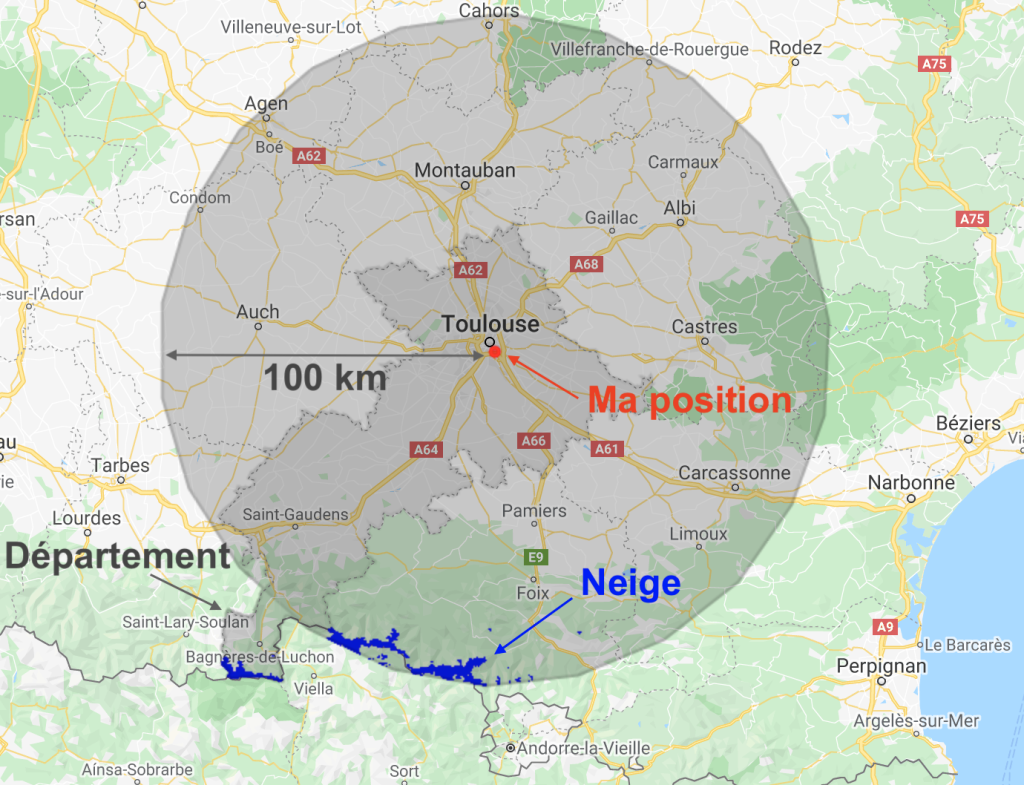
snow-ice

My remote sensing analyses on Twitter. Part 2: landslides

I started to look at landslides in satellite images when I saw this tweet by @RemotePixel: July 11th 2016 Sentinel-2 Image over Glacier Bay, AK massive landslide! pic.twitter.com/pTnHQ7el8G — Remote Pixel (@RemotePixel) July 14, 2016 Like floods, landslides can be quickly identified using a before/after image comparison. In the case of the Glacier Bay landslide […]

20.01.2020

My remote sensing analyses on Twitter. Part 1: floods

S. P. Hicks (@seismo_steve) wrote for Nature Geoscience a nice piece « Geoscience analysis on Twitter » where he shares his experience on using Twitter for the real time analysis of geohazards. Actively using Twitter for science may be perceived by some as a significant time-sink — the demands on individual researchers and their institutions at times […]

13.01.2020

Quelle est la probabilité d’avoir de la neige à Noël dans votre commune ?

La carte ci-dessous donne la probabilité d’avoir de la neige d’après les observations des trois dernières années. Voir en plein écran Pour produire cette carte j’ai calculé le nombre de fois où il y a eu de la neige le 25 décembre d’après les cartes d’enneigement Theia. Ces cartes sont établies à partir des images […]

20.12.2019

Persistent snow cover area in the Alps

These maps show the area that remained covered by snow from May 01 to Sep 01 over the past three years. It was computed from Theia Sentinel-2 snow products at 20 m resolution to capture the smallest snow patches.   In average there are about 1300 km2 (Lake Geneva: 680 km2) which remain snow-covered until […]

12.12.2019

20 m resolution snow maps, why bother?

« Snow varies. » (Snow scientist proverb) Sentinel-2 enables to generate snow maps at 20 m spatial resolution. But what’s the use of such high resolution snow maps? Because one picture is worth a thousand words, I resampled some Sentinel-2 images of snow-covered regions to coarser resolutions using the average reflectance of the contributing pixels. I did […]

05.12.2019

Juste une meilleure image de couverture pour l’article de Simon ci-dessous

28.11.2019

How to find the closest snow to you?

If you live in Pamiers near Toulouse, France, where is the snow-covered place that is the fastest accessible by car or by bike? There is a beautiful snow map of the Pyrenees mountains near Pamiers from a Sentinel-2 image that was acquired yesterday (at the time of writing) [link to the data]. In QGIS with […]

21.11.2019

Theia vous aide à trouver la neige la plus proche de chez vous

Si vous habitez à Pamiers, où se trouve la neige la plus rapidement accessible en voiture ? Theia nous fournit une belle carte de l’enneigement du 19 novembre 2019 dans les Pyrénées ariégeoises (lien vers les données). Dans QGIS avec l’API OpenRouteService on peut calculer les isochrones pour un trajet en voiture depuis Pamiers : […]

The flow of Pine Island Glacier in Antarctica as seen by Sentinel-1

The clip below shows the evolution of Pine Island glacier ice tongue in West Antarctica, from June 2017 to October 2019. I made it with 111 quicklooks of Sentinel-1 radar images processed by the Alaska Satellite Facility and available via the vertex data portal. All images were acquired in interferometric wide swath mode (polarization HH, […]

05.11.2019

Rechercher