snow-ice

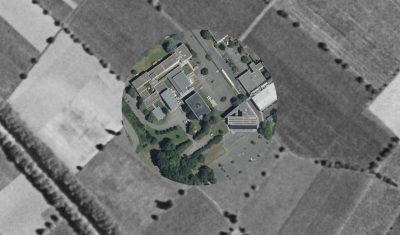
L’IGN nous fait remonter le temps

L’IGN a mis en ligne un outil formidable pour comparer les photos aériennes des années 1950 avec des prises de vue récentes. Cela permet d’explorer à l’envi l’évolution des paysages, comme par exemple la reforestation des estives dans les Pyrénées (ici le secteur de l’étang de Lers, en 2016 et 1953). Ou bien le retrait […]

02.02.2019

Near-real time analysis of the 2018-2019 snow season in the Pyrenees and the Alps from satellite data

Here in southwest France ski lovers did not really enjoy the beginning of the snow season… But how does it compare to the previous years? Using Sentinel-2 and Landsat-8 data, we computed the snow cover duration since September 01 until January 20 for the past three snow seasons in the Alps and Pyrenees.

25.01.2019

Two billion pixels to check your next ski destination

More exactly: two maps of 934’343’100 pixels! We [1] have processed 6205 Sentinel-2 images and 593 Landsat-8 images to compute the annual snow cover duration in the Alps and the Pyrenees at 20 m resolution for hydrological years 2016-2017 and 2017-2018. The snow cover duration (or snow persistence) is defined as the total number of […]

12.12.2018

The Khumbu Icefall by Venµs

This is a time-lapse of all clear-sky images captured by Venµs over the Khumbu Icefall near Mount Everest since November 2017 (one year of data, 51 images at 5 m resolution) . Here I used the Level-1C products (i.e. without atmospheric correction) because the Level-2A products are provided at a lower resolution (10 m). Anyway, […]

09.11.2018

Sentinel-2 Level3A time series (July, August, September 2018)

If you are not afraid to spend too much time while you have urgent things to do, you may have a look to the mosaic of Sentinel-2 monthly syntheses for September over France. You may access to each monthly synthesis using the following links :  Or you may also use the viewer below to compare […]

29.10.2018

Snow cover duration from 01 Sep 2017 to 31 Aug 2018 in the Alps and Pyrenees

=> We are thinking to distribute a new product that would provide the snow cover duration in the Alps and the Pyrenees over a hydrological year (snow persistence map). Here is a preview of a « beta » version that is only 100 m resolution for now.   A few words on the method (see also here): this […]

25.10.2018

Durée d’enneigement dans les Alpes et les Pyrénées du 01/09/2017 au 31/08/2018

=> Nous sommes en train de penser à un nouveau produit qui donnerait la durée d’enneigement dans les Alpes et les Pyrénées au cours de la dernière année hydrologique. Voici ci-dessous un aperçu d’une version « beta » (artisanale) qui n’est qu’à 100 m de résolution pour l’instant.   Quelques mots sur la méthode (voir aussi ici) : […]

Sentinel-2 captured a jökulhlaup in Afghanistan

In the Landslide blog Dave Petley has analyzed Planet images of the Pashgor debris flow in Afghanistan (here and here). Here I used two Sentinel-2 images (before and after the event) to show the path of the debris flow from the high mountain area to the Panjshir Valley. Sentinel-2 images have a lower spatial resolution […]

03.09.2018

Using Sentinel-2 to prepare your hike

The departmental council of the Alpes de Haute-Provence has put online 6,500 km of hiking trails throughout its territory. These trails are visible on the site www.rando-alpes-haute-provence.fr which works with Geotrek software. To allow hikers to better prepare their outing, it might be useful to add the 20 m resolution snow maps produced by Theia […]

25.07.2018

Rechercher