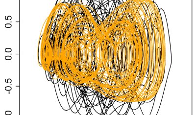
In English

Iceberg B-22A on the go

B-22A is the largest iceberg in the Amundsen Sea, Antarctica (50 times Manhattan land area). It broke off from Thwaites Glacier’s tongue and remained grounded for 20 years.. But now it’s on the go, as shown by this animation I made from Sentinel-1 SAR images (about 1 per month since June 2015, total 75 frames): […]

En Français

Manque de neige et de données dans les Pyrénées Orientales

J’étais hier dans la maison du parc naturel régional des Pyrénées Catalanes pour discuter des possibilités offertes par la télédétection pour suivre le manteau neigeux. Les participants à la réunion représentaient bien les différents usages de l’eau dans ce territoire (milieux naturels, agriculture, eau municipale, hydro-électricité, domaines skiables). Tous ont exprimé le besoin de mieux […]

En Français

Multitemp blog is now 10 years old

10 years ago, I managed to convince CNES to change the orbit of SPOT4 when it reached its end of life, to place it on a 5 days repeat orbit, in order to simulate the repetitive observations of Sentinel-2. It was the SPOT4 (Take5) experiment. We managed to distribute Sentinel-2 like data (With L1C, 2A […]

In English

Some news from ESA regarding the coming launches of Sentinels 1 and 2

In this article, ESA gave us some news of the time table for the coming launches of next Sentinel1 and 2 satellites. As you may have heard, we have these days a shortage of European launchers, due to the ending of Soyouz launches from Kourou, the delays in Ariane 6 delivery, and the initial uncertainties […]

3D

Feedback on hydrological monitoring of Telangana region in India using remote sensing

=> Claire Pascal, PhD student at CESBIO, under the supervision of Olivier Merlin (CNRS researcher) and Sylvain Ferrant (IRD researcher) brilliantly defended her thesis on the monitoring of water resources by satellite on November 18. Claire’s work focused on the Telangana region of India where rainfed cotton and flooded rice farming dominate. The region has […]

In English

[VENµS] How long will the VM5 imaging phase last ? The sun will decide

The VENµS satellite was launched in August 2017, with two missions : As a result, VENµS has had different phases separated by orbital changes. It’s imaging phases are VM1 at 720 km altitude, which lasted for three years, and the current VM5 phase at 560 km altitude, which started in March 2022. So, what will […]

3D

Retour d’expérience sur le suivi hydrologique d’une région Indienne par télédétection

=> Claire Pascal, doctorante au CESBIO, sous la direction d’Olivier Merlin (chercheur CNRS) et co-dirigée par Sylvain Ferrant (chercheur IRD) a brillamment soutenu sa thèse sur le suivi des ressources en eau par satellite le 18 novembre. Les travaux de Claire se sont focalisés sur la région du Telangana en Inde où la culture non […]

In English

[THEIA] Near real time production of Sentinel-2 images has resumed

Due to Brexit,  the ECMWF moved some of its computer infrastructure from Reading (UK) to Bologna (IT), and a 5 week interruption of service occurred for the production of Copernicus Atmosphere Monitoring Service. As our Level 2A production for Sentinel-2 uses this information to set the type or aerosols for the atmospheric correction, we had […]

In English

Sample images from VENµS new phase are available

Here are some long awaited news about the VENµS VM5 phase. The acquisitions started end of March 2022 with the following list of sites, and should go on for at least one year, and maybe more depending on the consumption of fuel (Hydrazine) to maintain the orbit. Most of the sites are acquired with a […]