In English

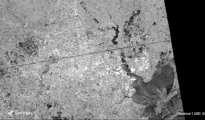
Flooded areas in Houston by Sentinel-1

Hurricane Harvey hit Texas on August 25. The first Sentinel-1 image of Houston since landfall was acquired on Aug 29 at 00:26 UTC. I’m writing this post at 21:09 UTC. As reported by the local news website chron.com « The most severe flooding is around the Highway 90 and Eastgate areas ». This is also what we […]

Applications

Les Sentinels témoins de la déforestation en Amazonie

Le Monde.fr a publié un reportage frappant « Au Brésil, avec les policiers qui luttent contre la déforestation de l’Amazonie« . Le journaliste et photographe Bruno Kelly a suivi les agents de l’institut pour l’environnement et les ressources naturelles renouvelables (Ibama) dans les environs d’Apui, une petite localité isolée au sud de l’état d’Amazonas. Il écrit que […]

En Français

Les premières images de Venµs

=>Les vrais produits du nouveau satellite Venµs seront des séries temporelles d’images de la terre (pas la planète Venus), acquises tous les deux jours sur plus de 100 sites. Mais pour obtenir ces séries temporelles, il faut que Venµs soit sur son orbite nominale, qu’il rejoindra courant septembre. Mais nous sommes déjà très heureux de […]

Venµs

Venµs first images

=> The real products from the new Venµs satellite, will be time series of high resolution images of the Earth (not Venus planet) acquired every second day on more than 100 sites. But to get these time series, Venµs needs to be on its nominal orbit, which will be reached beginning of September. Anyway, we are […]

In English

Vavilov Glacier in 2016 and 2017

The organizers of the 2017 International Glaciology Society meeting in Boulder tweeted this animation of the Vavilov Glacier (October Revolution Island, Russian Arctic):

Non classé

Sentinel-2 ground segment restarted, but a backlog remains to be processed

From Scihub news : Referring to the news of 11 August , users are informed that the contingency issue occurred at Matera has been solved and nominal Sentinel-2A/B production was restarted yesterday 16 August in the early afternoon.An inventory of the missing production is being consolidated and all impacted S2A/B L1C products will be recovered […]

Applications

THEIA distributes L2A Sentinel-2 data over Italy, Switzerland, and most of Alps

Done ! All Sentinel-2 data acquired above Italy, Switzerland and Austrian Alps, and processed at level 2A, are now available on Theia website! The data format is described here. We would be very thankful if users in Italy or Switzerland could help us spread the news among remote sensing users in both countries. The level 2A […]

En Français

An anomaly provisionally prevents real time production in ESA’s Sentinel-2 ground segment

That’s bad luck, just before the long week-end of the 15th of August, ESA Sentinel-2 ground segment failed and ceased production. This explains why Theia ground segment is not producing in real time anymore.Pas de chance, le segment sol de Sentinel-2 À L’ESA est tombé en panne juste avant le week-end du 15 août. Ceci […]

CESBIO

NASA selected CESBIO’s land cover map of France as « image of the day »

=> It is a well deserved recognition for the land cover product developed at CESBIO : NASA’s earth observatory blog dedicated its « image of the day » blog post for the 15th of August to this product. This work was done in the framework of Theia, using iota2 free software also developed at CESBIO. Thanks to the information conveyed […]