In English

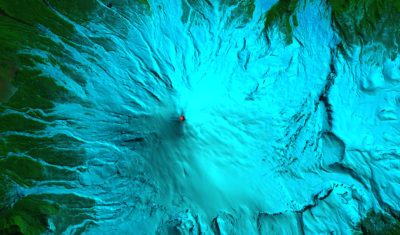
Snow cover in the High Mountain Asia on 13 May 1960

TIROS-1 weather satellite was launched by NASA on 01 April 1960. It took the first weather satellite picture on 02 April 1960 [1], and also the real first weather satellite picture on 01 April 1960 [2]. On 02 April 1960, it also captured what I believe is the first publicly available satellite picture of the snow […]

Applications

Enneigement des Deux Alpes en octobre 2017

Le 13 octobre on apprenait que le glacier des 2 Alpes n’ouvrira exceptionnellement pas à la Toussaint. Une décision prise en raison de précipitations insuffisantes et des températures élevées cet automne. J’ai fait tourner la chaîne Let-it-snow pour jeter un coup d’œil aux conditions d’enneigement. Hier Theia a mis à disposition l’image Sentinel-2A acquise mardi […]

In English

Yellow skies look grey from above

You must have seen, in the press or social networks, images like these ones, showing yellow skies ( Loup de Bretagne said « Blade Runner skies »). Such a coloured sky was seen in the west of France, then later in England, and further East in the next days.The Copernicus Atmosphere Monitoring Service, which keeps track of […]

Applications

Validation et amélioration des produits Theia Surfaces Enneigées à partir d’images haute résolution

Post préparé par Marine Bouchet pour le blog Kalideos Alpes (version originale) Les séries temporelles d’images optiques des satellites Sentinel-2 permettent un suivi de la surface enneigée à une résolution spatiale de 20 m tous les 5 jours (en l’absence de nuages). Le CNES et le CESBIO développent, depuis 2015, une chaîne Let It Snow […]

PEPS

[Muscate news] temporary slowlyness

Update : MUSCATE is back on track for the real time production, thanks to PEPS return to nominal production, and a better stability of our platform.Some of you will have probably noticed that Theia production of Sentinel-2 L2A data is quite slow these days, and is not producing all the data it should in real […]

In English

Hot N Cold: Villarrica Volcano

Villarrica volcano is one of the most active volcanoes in the Chilean Andes. A colleague of mine (Esteban Alonso) told me that last week he went ski touring up there and when he reached the summit he could see the bubbling lava in the bottom of the crater, and could even feel its heat…

Image quality

Venµs’ moon

=>Well, the audience of our blog is still steady increasing, there is no need to use explicit titles to get more connexions. And although I mainly use space to look down, I do not think the planet has a natural satellite. So why this title ?The Venµs satellite actually showed us the moon, and not […]

En Français

Quand Venµs nous montre la lune

=>Non, non, la fréquentation de ce blog n’est pas en baisse au point qu’il nous faille attirer une nouvelle clientèle pour compenser une perte de revenus financiers issus de la publicité. (La fréquentation augmente régulièrement d’ailleurs, mais les revenus financiers sont nuls…)Le satellite Venµs nous a vraiment montré la lune, et ce n’est pas seulement […]

Applications

Soil moisture maps at a high resolution over Occitania region

=> Translated from Theia website.The Theia forges just released a new product based on Sentinel-1 and 2 data. Le « High resolution soil moisture » Scientific Expertise Center, driven by Nicolas Baghdadi, from Tetis lab in Montpellier and Mehrez Zribi from CESBIO, distributes Soil Moisture maps from the French Occitania region at 20 m resolution, produced every […]