Theia just selected a new production zone for Sentinel-2 L2A in Sahel
![]() =>
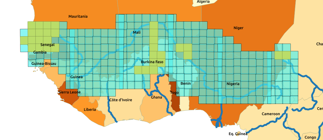
=> ![]() The Level 2A data production with MAJA processor, by MUSCATE processing center is now fast and efficient. Some margins have been found to add new zones to our production. (The zones already processed are displayed here). French public institutes of labs that would need new zones can tell us their needs, we should still have a few tiles left in our quota. A few well informed colleagues acted fast, and Santiago Pena Luque (from CNES), who works for the SWOT satellite project made a large new proposal. The Senegal and Niger basins which have been chosen as integrative test sites by SWOT. So the main target is to monitor the height and flow of the rivers, but this implies to study rainfall, evapo-transpiration and run off. The Sentinel-2 data will provide the vegetation status. Of course, the same zone will also allow a large variety of applications related to climate, desertification, food production monitoring, starting from land cover. Several laboratories are associated to the proposal: namely, GET, LEGOS and CESBIO in Toulouse, and TETIS in Montpellier. Here is the zone that was accepted by Theia today :
The Level 2A data production with MAJA processor, by MUSCATE processing center is now fast and efficient. Some margins have been found to add new zones to our production. (The zones already processed are displayed here). French public institutes of labs that would need new zones can tell us their needs, we should still have a few tiles left in our quota. A few well informed colleagues acted fast, and Santiago Pena Luque (from CNES), who works for the SWOT satellite project made a large new proposal. The Senegal and Niger basins which have been chosen as integrative test sites by SWOT. So the main target is to monitor the height and flow of the rivers, but this implies to study rainfall, evapo-transpiration and run off. The Sentinel-2 data will provide the vegetation status. Of course, the same zone will also allow a large variety of applications related to climate, desertification, food production monitoring, starting from land cover. Several laboratories are associated to the proposal: namely, GET, LEGOS and CESBIO in Toulouse, and TETIS in Montpellier. Here is the zone that was accepted by Theia today :
The new zone was defined from the following constraints:
- Cover the Senegal and Niger basins
- No more than 300 new tiles (288 exactly)
- Add a contiguous zone
- Avoid the Guinea gulf coast as it is mostly cloudy
- Avoid the desert, as it does not change much with time
- Try to complete administrative units (countries, regions)
The final zone covers the Sahel from Senegal to Tchad, including the whole Senegal, Gambia, Burkina Faso, the South and West of Mali, the North of Guineas, Ivory coast, Ghana, Togo, Benin, Nigeria, The South-West of Niger and the West of Chad.We will start the processing with the data acquired in December 2016, and try to catch-up the real time production as fast as possible. Given the size of the zone, it will take a few months probably. That’s a lot of work for the MUSCATE production team, but it will be useful 🙂


