A mining company doing land art?

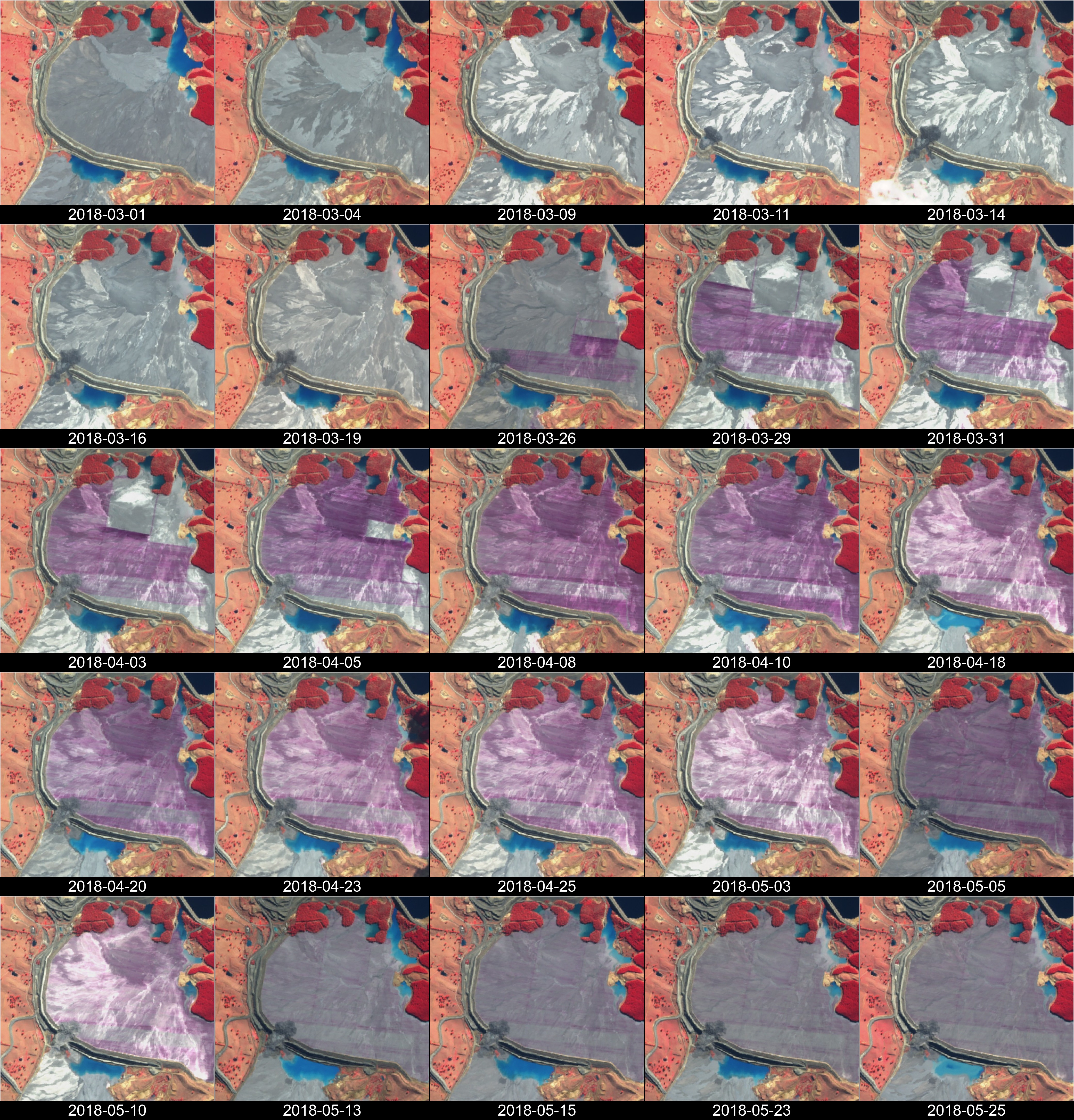
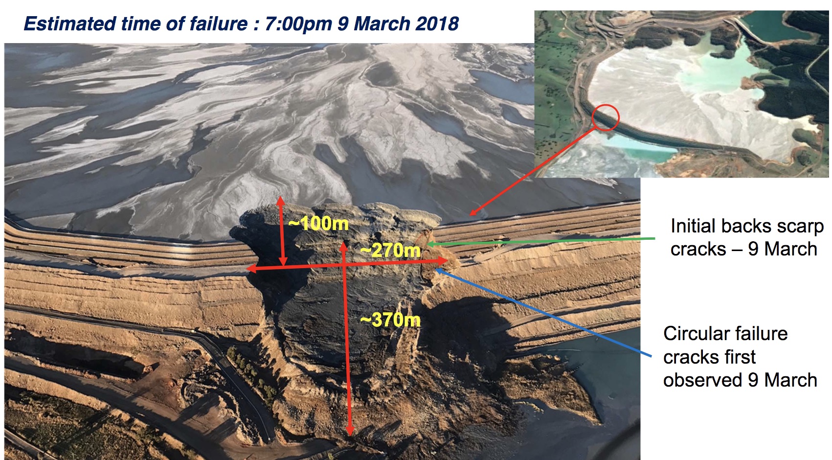
On March 9th, 2018, a tailings dam has failed at Cadia, a large open pit gold mine in Australia. Dave Petley for the AGU landslide blog collected aerial and satellite (Planet) images of the dam before and after the event. The Newcrest mining company also published a report on the failure.

Cadia mine embankment slump dimensions (source: Newcrest, Cadia Northern Tailings Facility Presentation and Webcast, 15 March 2018)

The embankment slump is also clearly visible in Sentinel-2 imagery. Here I used a near-infrared compositing because it enhances the contrast between the vegetation (bright in the near-infrared) and the water (dark in the near-infrared). When I did this animation, I was not expecting to see this progressive color change in the northern tailings — as if someone was methodically painting the landscape?  

Tim Barrows and Dave Petley kindly helped me figure out that this is a crusting agent spread by an aircraft. This type of product is used to prevent dust lift off.  The aircraft is visible in this video by Jeremy Buckingham. According to him, the Newcrest company is spreading this crusting agent because the tailings deposit became very dry after the dam failure. Jeremy is a New South Wales Member of Parliament, with the portfolio interests of Mining and Gas extraction and affiliated to the Australian Greens. I trust him when he says that he’s smarter than he looks. In fact, his explanation sounds better than my land art hypothesis…

Plus d'actualités

BIOMASS, the third launched satellite mission designed at CESBIO !

After SMOS in 2009, and VENµS in 2017, the CESBIO laboratory is very proud to see its third proposed mission, Biomass, reach orbit. As always, it has been a long journey from the idea, at the beginning of the century, to the selection in 2013 as the seventh Earth Explorer Mission by ESA, to the […]

Sentinel-2 reveals the surface deformation after the 2025 Myanmar earthquake

Sentinel-2 captured several clear-sky images of Myanmar before and after the 28 March 2025 earthquake. The animation below shows a 5-day apart sequence of images captured by Sentinel-2B and Sentinel-2C (10 m resolution) near the epicenter located close to Mandalay. The surface slip due to the earthquake follows the Sagaing Fault, a major fault in […]

Evolution de l’altitude de la ligne de neige au cours des 41 dernières années dans le bassin versant du Vénéon (Oisans)

Pour contribuer à caractériser les conditions hydrométéorologiques lors de la crue torrentielle qui a frappé la Bérarde en juin, j’ai analysé une nouvelle série de cartes d’enneigement qui couvre la période 1984-2024 [1]. Grâce à la profondeur temporelle de cette série, on constate que l’altitude de la ligne de neige dans le bassin versant du […]

Rechercher