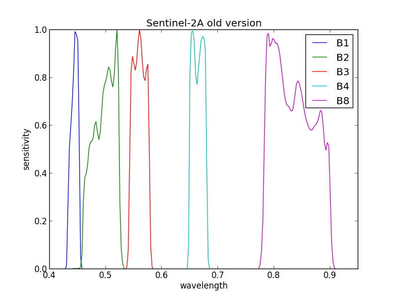
Revised spectral bands for Sentinel-2A

The Sentinel-2 mission status document, edited by ESA, is a very interesting reading. On its last edition of 2017, ESA announced very discretely that the spectral bands of Sentinel-2 had been revised, following a review of the pre-flight measurements. Very few details are provided on the nature of the error contained in the previous version, and on the validation of the new ones. But still, a new version of the spectral response function is available here,, since the 19th of December 2017. The site provides an excel file with the spectral response functions.All the visible and near infrared bands have changed a little, even if only three bands have significant changes, B1, B2 and B8: B2 equivalent wavelength changes by 4 nm, B1 by 1 nm, and B8 by 2 nm. The SWIR bands did not change.

Most users should not use bands B1 and B2, as they are affected by atmospheric effects. So I do not think much of you will have to change the coefficients in your methods. But for us, who take charge of the atmospheric correction, and heavily rely on B1 and B2, it probably has an effect, and we are changing our look-up tables to account for that. Stay tuned for the results.

Plus d'actualités

BIOMASS, the third launched satellite mission designed at CESBIO !

After SMOS in 2009, and VENµS in 2017, the CESBIO Laboratory is very proud to see its third proposed mission, Biomass, reach orbit. As always, it has been a long journey from the idea, at the beginning of the century, to the selection in 2013 as the seventh Earth Explorer Mission by ESA, to the […]

Sentinel-2 reveals the surface deformation after the 2025 Myanmar earthquake

Sentinel-2 captured several clear-sky images of Myanmar before and after the 28 March 2025 earthquake. The animation below shows a 5-day apart sequence of images captured by Sentinel-2B and Sentinel-2C (10 m resolution) near the epicenter located close to Mandalay. The surface slip due to the earthquake follows the Sagaing Fault, a major fault in […]

Evolution de l’altitude de la ligne de neige au cours des 41 dernières années dans le bassin versant du Vénéon (Oisans)

Pour contribuer à caractériser les conditions hydrométéorologiques lors de la crue torrentielle qui a frappé la Bérarde en juin, j’ai analysé une nouvelle série de cartes d’enneigement qui couvre la période 1984-2024 [1]. Grâce à la profondeur temporelle de cette série, on constate que l’altitude de la ligne de neige dans le bassin versant du […]

Rechercher