Watching ice shelves break up with Sentinel-1

The animation below shows the evolution of Thwaites glacier eastern ice shelf in West Antarctica, from July 2016 to May 2017. I made it with 45 quicklooks of Sentinel-1 radar images processed by the Alaska Satellite Facility and available via the vertex data portal. All images were acquired in interferometric wide swath mode (polarization HH, only ascending passes, path: 65, frame: 914) and projected to ground range.


This area was imaged almost every 6 days by Sentinel-1A and Sentinel-1B with a constant observation angle. Radar imagery is important in polar regions to track icebergs during the polar night. In this sequence we can see many icebergs drifting in the Amundsen Sea. In April 2017, just before the winter onset, two big icebergs calved from the Thwaites ice shelf. Did you know that the U.S. National Ice Center (NIC) assigns a name to the largest Antarctic icebergs? According to the NIC tables I think these are iceberg B42 and B43. Iceberg B42 had a length of 17 nautical miles (31 km) in the update of May 19, 2017.
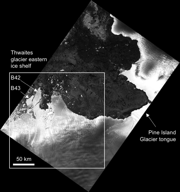
Sentinel-1B image acquired on 2017 Apr 03

(Edit on Oct 24, 2017) I extended the video to the period Feb 2015 to Sep 2017 (214 frames, this time I had to use Google Earth Engine) 


Plus d'actualités

IOTA2 software mailing list

Hello everyone, We have just created a mailing list for users of the IOTA2 software (iota2 — iota2 documentation). The tool will undergo significant developments in the coming months, and the purpose of this list is to communicate with the community to support these changes and to maintain the processing workflows needed by the users. […]

Evolution des glaciers du Vignemale sous l’œil des satellites Pléiades (2013-2025)

Grâce à DINAMIS, un couple d’images stéréoscopiques a été acquis par Pléiades 1B le 14 septembre 2025. Le modèle numérique de surface (MNS) produit à partir de ces images peut être comparé à un autre MNS de septembre 2013 produit à partir des images Pléiades 1A commandées par Marti et al. (2014). Le glacier d’Ossoue […]

Rapid analysis of the GLOF in Gupis, Gilgit-Baltistan

Pakistan news media reported that a glacier lake outburst flood (the failure of a dam containing a glacial lake) occurred near Gupis, Gilgit-Baltistan, a highly mountainous region administered by Pakistan. Satellite images show that the flood triggered a debris flow, which reached the Gupis valley where it hit the Roshan (Rashon) village and blocked the […]

Rechercher