
Ice breaker
 =>
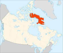
=>  Among the sites observed by SPOT5 (Take5), there was the Baffin Island, in the North of Canada. The cloud cover was very high on that site, but it still let us observe the snow melt over land, and the sea ice disappear. As you will see below, it is fascinating to see how the ice cover breaks into pieces. I guess specialits could tell us lots of things on this time series, but I am not a specialist. If you happen to be a specialist, your comments will be welcome ! Summer is short at this lattitude, and as early as the first of September, the snow is back in the mountains, and ten days later, one of the inlets starts to freeze. A large Iceberg did not have time to melt during that summer, and if you look closely at the first images, it seems the iceberg was already stuck there all winter. During summer, the slopes oriented towards South have taken a greenish tint, sign that a few mosses or weeds had time to grow.

