THEIA

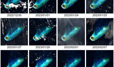
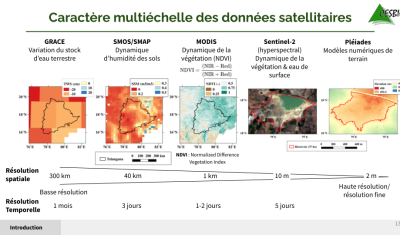
A new downloader to access individual files within the zip distributed by THEIA

Downloading time series from Theia can take a while, depending on the area and the time period covered by the images. Also, it consumes a lot of storage locally, since all the archives in .zip format have to be downloaded (the GeoDataHub will probably distribute Cloud Optimized Geotifs). From my experience, a lot of people […]

21.03.2023

[VENµS] production of VM5 images restarts

We have had to cancel the production of VENµS L1C and L2A products for one month, because the footprints of VENµS images tend to change more than anticipated. The ground segment recognizes the sites by the coordinates of the corners, and the tolerances were not large enough. This problem has been understood and corrected by […]

14.03.2023

Geodes, futur centre d’accès aux données du CNES pour l’observation de la terre

=> Contexte En 2021, le CNES a décidé de mettre en œuvre un hub de services autour de la diffusion des données satellitaires d’Observation de la Terre (OT). Intégré dans un écosystème national et européen, dans le cadre de Data Terra et au service des communautés scientifiques et des projets du CNES, le projet Geo […]

07.03.2023

A 10 m resolution land cover map of Sahel with iota2

iota2 is the large scale mapping software developed at CESBIO. iota2 takes high resolution satellite image time series (SITS), usually Sentinel (1 and 2) or Landsat, and produces maps over large areas. Maps of most usual variables of interest in remote sensing can be produced, since iota2 can compute user-defined functions at the pixel level, […]

09.01.2023

Feedback on hydrological monitoring of Telangana region in India using remote sensing

=> Claire Pascal, PhD student at CESBIO, under the supervision of Olivier Merlin (CNRS researcher) and Sylvain Ferrant (IRD researcher) brilliantly defended her thesis on the monitoring of water resources by satellite on November 18. Claire’s work focused on the Telangana region of India where rainfed cotton and flooded rice farming dominate. The region has […]

01.12.2022

Retour d’expérience sur le suivi hydrologique d’une région Indienne par télédétection

=> Claire Pascal, doctorante au CESBIO, sous la direction d’Olivier Merlin (chercheur CNRS) et co-dirigée par Sylvain Ferrant (chercheur IRD) a brillamment soutenu sa thèse sur le suivi des ressources en eau par satellite le 18 novembre. Les travaux de Claire se sont focalisés sur la région du Telangana en Inde où la culture non […]

10.11.2022

[THEIA] Near real time production of Sentinel-2 images has resumed

Due to Brexit,  the ECMWF moved some of its computer infrastructure from Reading (UK) to Bologna (IT), and a 5 week interruption of service occurred for the production of Copernicus Atmosphere Monitoring Service. As our Level 2A production for Sentinel-2 uses this information to set the type or aerosols for the atmospheric correction, we had […]

02.11.2022

Sample images from VENµS new phase are available

Here are some long awaited news about the VENµS VM5 phase. The acquisitions started end of March 2022 with the following list of sites, and should go on for at least one year, and maybe more depending on the consumption of fuel (Hydrazine) to maintain the orbit. Most of the sites are acquired with a […]

Effet de la sécheresse 2022 sur la durée d’enneigement dans les Parcs Nationaux

A partir des produits neige Theia, j’ai calculé la durée d’enneigement entre le 1er juin et le 31 août à 20 m de résolution spatiale pour chaque année depuis 2017 dans les zones cœurs des quatre Parcs Nationaux français de haute montagne (Pyrénées, Vanoise, Écrins, Mercantour). A titre d’illustration voici la comparaison entre l’été 2022 […]

14.09.2022

Rechercher