Satellite Missions

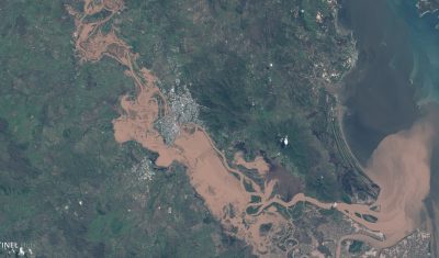
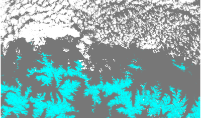
Using the NDWI to map flooded areas in the Central US

These Sentinel-2 images show the extent of the recent flooding near the border between Arkansas and Missouri on Apr 24, 2017 (36°30’N 90°38’W). The left image is a natural color composite (similar to what our eyes could see if we were in orbit). The right image is a color representation of the Normalized Difference Water […]

04.05.2017

The 2017 Queensland floods

The Google Earth Blog spotted the recent Queensland floods in Sentinel-2 imagery. The Sentinels provide systematic coverage of the land areas, which facilitates the detection of changes due to natural hazards. Hence we can compare this Sentinel-2A image with another one that was captured last year during the same season to better highlight the extent […]

02.05.2017

Sentinel-2 adds colors to the 2017 super bloom in California

Texas had the super bowl in 2017 but California got the super bloom! After its worst drought in 1,200 years, California is now experiencing one its wettest year. The Sierra Nevada snowpack is currently one of the biggest ever recorded. In February, severe winter rainfalls caused the evacuation of many California residents under the threat of […]

27.04.2017

Last Sunday’s snow cover map from Sentinel-2

We know that fast distribution of satellite products is critical for many applications, including the planning of your next weekend. Olivier just announced that Theia is now delivering Sentinel-2 Level 2A data in near real time. This is great because today I was able to make the snow cover map of the Pyrenees on Sunday at […]

20.04.2017

10000 L2A products available at Theia for Sentinel-2

The number of L2A products from Sentinel-2 available at Theia, just passed above 10 000 ! Data from France, Belgium, North of Spain, Morocco, Tunisia, Senegal, the Burkina-Mali transect, or La Reunion Island are now processed in real time : our requirement is 60 hours, after the data is available in Copernicus hub. Next site […]

15.04.2017

They did it / Ils l’ont fait

06.04.2017

Senegal Sentinel-2 L2A data available at Theia

One year of Senegal S2A L2A data available at https://theia.cnes.fr/atdistrib/rocket/#/search?q=Senegal&?lang=enUne année de données S2A de niveau 2A sur le Sénégal disponibles depuis https://theia.cnes.fr/atdistrib/rocket/#/search?q=Senegal&?lang=en  

THEIA/MUSCATE nears real time for Sentinel-2 L2A

THEIA MUSCATE production of Sentinel-2 L2A products nears real time, and L2A products acquired until March 2017 over France and Reunion Island have started to appear on our distribution server : The production will progressively be extended over the whole France and over the other sites (Spain, Morocco, Belgium Tunisia, Senegal, Burkina, Mali…) and then […]

05.04.2017

Quantitative comparison of cloud masks from MACCS/MAJA, Sen2Cor and GEOSYS (hand made)

=> As already explained in a previous post, we obtained some Sentinel-2 hand made cloud masks from GEOSYS company. We used those to validate the cloud masks from MACCS/MAJA. But we wanted to use them further to make a quantitative comparison with Sen2Cor cloud masks.But this comparison required solving a little issue : GEOSYS cloud masks […]

03.04.2017

Rechercher