Satellite Missions

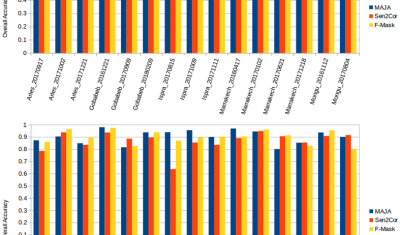
Sentinel-2 Level 3A products : syntheses or composites ?

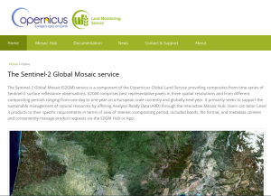
=> For the past few months, Copernicus has been distributing Level 3A products for the Sentinel-2 mission as part of the S2GM (Sentinel-2 Global Mosaics) . This ambitious project aims to provide monthly, quarterly or annual Level 3A products worldwide. The user defines his zone and period of interest and orders the product. The web site […]

03.03.2019

Produits de Niveau 3A: Synthèses ou composites ?

=>Copernicus diffuse depuis quelques mois des produits de niveau 3A pour la mission Sentinel-2 dans le cadre du projet S2GM (Sentinel-2 Global Mosaics). Ce projet très ambitieux a pour but de fournir, à l’échelle mondiale, des synthèses mensuelles, trimestrielles ou annuelles. L’utilisateur définit sa zone et sa période d’intérêt et commande le produit. Le site est […]

New paper ! An active learning cloud detection tool to generate reference cloud masks for Sentinel-2. Application to the validation of MAJA, Sen2cor and FMask cloud masks

It is not that frequent when the work of a trainee ends up as a peer reviewed publication, but Louis Baetens was a brilliant trainee. In a six months training period at CESBIO, funded by CNES, here is what Louis Baetens did: The publication was just released by remote sensing :Baetens, L.; Desjardins, C.; Hagolle, […]

20.02.2019

A pause in MUSCATE production, end of February

The MUSCATE production centre will be offline for a week from February 25th to March 4th (or maybe the week after, please see Theia’s RSS feed to see the exact date). This pause will be necessary to upgrade the processing centre to V2.5. As a result, we will not be able, for a week, to […]

19.02.2019

Black snow in Prokopyevsk

The snow cover is not always white. Sometimes it is orange, sometimes it is black. The images below were captured by Sentinel-2 in Prokopyevsk, Russia.According to the Siberian Times the deposition of black dust on snow in February 2019 was due to the failure of a filtering system in a coal processing plant. Looking at […]

18.02.2019

Apport des images radar et optiques pour la cartographie des surfaces irriguées

(English version below) Dans le cadre du projet Simult’eau (partenaires : Arvalis, CACG, Chambres d’Agriculture du Tarn et des Hautes-Pyrénées, financement CASDAR) nous avons testé l’apport d’une utilisation combinée des images radar et optiques pour la cartographie des surfaces irriguées (maïs et soja) dans le Sud-Ouest de la France. Les résultats publiés dans Remote Sensing […]

12.02.2019

Release of MAJA 3.2

The version 3.2.2 of MAJA cloud detection and atmospheric correction software has just been released! It brings a lot of improvements. It can be used to process Sentinel-2 data in four different manners that will be described below : Improvements

11.02.2019

Diffusion d’un premier lot des données Sentinel-2A de niveau 2A sur le Sahel

Il y a quelques semaines, nous annoncions la sélection d’une nouvelle zone de production de données Sentinel-2 au niveau 2A par Theia, au Sahel. La production a démarré, et Theia a déjà produit les tuiles de la zone UTM28 (à l’ouest). Les tuiles en vert foncé existaient déjà, mais nous avons rajouté celles en vert […]

06.02.2019

S1-Tiling, on demand ortho-rectification of Sentinel-1 images on Sentinel-2 grid

=> Sentinel-1 is currently the only system to provide SAR images regularly on all lands on the planet. Access to these time series of images opens an extraordinary range of applications.In order to meet the needs of a large number of users, including our needs, we have created an automatic processing chain to generate « Analysis […]

30.01.2019

Rechercher