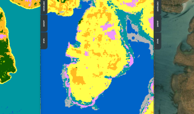
In English

[VENµS] How long will the VM5 imaging phase last ? The sun will decide

The VENµS satellite was launched in August 2017, with two missions : As a result, VENµS has had different phases separated by orbital changes. It’s imaging phases are VM1 at 720 km altitude, which lasted for three years, and the current VM5 phase at 560 km altitude, which started in March 2022. So, what will […]

15.11.2022

[THEIA] Near real time production of Sentinel-2 images has resumed

Due to Brexit,  the ECMWF moved some of its computer infrastructure from Reading (UK) to Bologna (IT), and a 5 week interruption of service occurred for the production of Copernicus Atmosphere Monitoring Service. As our Level 2A production for Sentinel-2 uses this information to set the type or aerosols for the atmospheric correction, we had […]

02.11.2022

Sample images from VENµS new phase are available

Here are some long awaited news about the VENµS VM5 phase. The acquisitions started end of March 2022 with the following list of sites, and should go on for at least one year, and maybe more depending on the consumption of fuel (Hydrazine) to maintain the orbit. Most of the sites are acquired with a […]

First satellite images of Nord Stream leaks

I found the leak from Nord Stream 2 in the latest Sentinel-1 image (29 Sep 2022). It’s large enough to be visible from space. From this radar image, I could also spot the leak in the Landsat image captured on the same day (29 Sep). And there’s another leak visible northeast of Bornholm Island, this […]

29.09.2022

We are hiring an expert (M/F) in scientific computing to improve MAJA

We are hiring an expert (M/F) in scientific computing to improve the consideration of aerosol type in the MAJA Earth observation image processing chain using machine learning methods. The aim is to explore single and multi-variable regression approaches in order to select the most efficient one, which is the result of a trade-off between simplicity […]

26.09.2022

Disruptions in the availability of Theia products

=> You may have noticed an interruption in the availability of level 2 and 3 products on the THEIA portal. This is due to ongoing disruptions in the availability of CAMS (Copernicus Atmosphere Monitoring Service) data used by the MAJA atmospheric correction chain. These disruptions are linked to the migration of the ECMWF data centre, […]

After 6 years of Copernicus data, I have never seen France that yellow

=> What can we say, except that the vegetation situation in France has worsened significantly in July 2022 compared to an already alarming June. The monthly syntheses of Sentinel-2 for the month of July are available since a few days, and the comparison with previous years shows an exceptional drought on the whole territory. Only […]

02.09.2022

INFERNO: a new software processing radar interferometry time series using Sentinel 1 products

=> The applications of interferometric techniques on radar images are currently developing in many fields. Being able to easily process and plot radar images, interferograms or time series of interferograms with a tool and data that are free and available without being a specialist is an important issue for scientists or companies that do not […]

01.09.2022

Dès juin 2022, la sécheresse s’étend à l’échelle continentale

=> Alors que l’Italie ou le Maroc s’alarment depuis des mois, la sécheresse s’est étendue en juin à toute l’Europe du Sud Ouest (qualifier la Bretagne de « Sud Ouest » est un peu osé, je le reconnais). Nous disposons des synthèses de réflectances de surface issues de Sentinel-2 pour le mois de juin depuis quelques jours, […]

02.08.2022

Rechercher