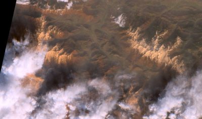
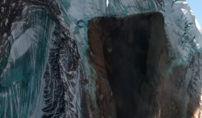
Applications

Copernicus Land – High-resolution Snow and Ice Monitoring: processing campaign status

  Snow and ice products are now available at high resolution (20×20 m) for all Europe in near-real time. However, Magellium is also processing the Sentinel-2 archive since September 2016. About 70% of Sentinel-2 observations have already been processed and 50 % are already published. This huge computation is being done on the CNES HPC […]

12.11.2020

Stealth snow near Albuquerque, New Mexico

« Give me a hundred tries, I’ll never be able to spell it. » Jimmy McGill I haven’t seen the « Breaking Bad » series but I’m a huge fan of « Better Call Saul ». Both series take place in Albuquerque, New Mexico. With its dry, sunny weather, Albuquerque is the perfect place for a modern-day Western. Vince Gilligan, the […]

08.11.2020

Modelos caóticos de baja dimensión para la micro-atmósfera de la cueva prehistórica de Altamira (España)

La aplicación de la técnica de modelización global a la micro-atmósfera de la cueva de Altamira ha permitido obtener modelos caóticos de baja dimensión a partir de las variaciones en su contenido de dióxido de carbono (CO2) y radón (222Rn), las cuales resultan de la actividad biológica del suelo y de un proceso físico de […]

30.10.2020

Using PEPS to compute the ground surface displacement after the Palu earthquake

The 7.5 magnitude Palu earthquake in 2018 was a disaster that left 2,081 people dead, 1,309 missing and 206,494 displaced. An impressive surface slip associated with the earthquake was visible in optical satellite imagery like Sentinel-2. I used this case to test the new tool that has been made availabe by the PEPS team (https://peps.cnes.fr/). This tool enables […]

14.10.2020

September snow captured by Sentinel-2

A sunny Sunday just after an exceptional late-September snowfall… That’s already a stroke of luck. But the passage of Sentinel-2 on the same day makes this weekend even more special! The snow cover map was immediately processed and distributed by the new Copernicus Snow & Ice monitoring service powered by Cesbio’s algorithms! You can explore […]

28.09.2020

Orpaillage sur le fleuve frontalier entre la Guyane et le Suriname : télédétection des dommages causés par les barges aux rives du Maroni

Le Suriname, comme l’ensemble du plateau des Guyanes, est touché depuis plus de trente ans par le fléau de l’orpaillage qui entraîne la destruction du couvert forestier, la pollution des cours d’eau, en impactant fortement l’environnement et les population locales. L’orpaillage y est dit primaire quand l’or est directement extrait de la roche-mère, alors qu’il […]

09.09.2020

Pic Saillant : la balade hydrologique du dimanche

En partant de Boutx (780 m) on peut monter au Pic Saillant (1756 m) (voir le topo) et admirer un magnifique panorama hydrologique sur le haut bassin de la Garonne et de son affluent la Pique. Par temps clair, on peut deviner les sommets du Luchonnais encore enneigés au mois de juillet qui marquent la […]

20.07.2020

Impact du COVID-19 sur la pelouse du Centre Spatial de Toulouse

Le CNES a publié sur LinkedIn ces jolies photos du Centre Spatial de Toulouse après le confinement. Grâce aux satellites d’observation de la Terre, les ingénieurs du CNES sont capables d’étudier la végétation aux quatre coins du globe. Mais, les cordonniers sont souvent les plus mal chaussés… Pourraient-ils étudier leur propre pelouse par satellite ? […]

26.06.2020

Debris flow in the Ishkoman Valley

In July 2018, the Pamir Times has reported that a lake formed due to a debris flow in the Ishkoman Valley, Pakistan. This event caused the destruction of dozens of housed in Badswat and Bilhanz villages. The flood debris running down the slope hit the mountain on the opposite side, and formed a barrier, blocking […]

23.06.2020

Rechercher