In English

MUSCATE news : release of Madagascar Sentinel-2 L2A data

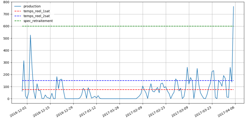
After a good period with very little production incidents, our Muscate facility has had a tough period, which almost halted the production for one week. Until last week, the Muscate ground segment was running on CNES older cluster, and was just using the new cluster’s bay of disks to store the input and output data. […]

Non classé

Issue with Firefox 53 on Theia distribution server

We recently figured out that the Theia distribution server is not fully compatible with the most recent version of Firefox (V53), and that the authentication fails, preventing from downloading products with that version. The teams are working to solve this, but meanwhile, please wait before updating your firefox browser. Nous nous sommes récemment aperçus que […]

Comment ça marche /how it works

Using the NDWI to map flooded areas in the Central US

These Sentinel-2 images show the extent of the recent flooding near the border between Arkansas and Missouri on Apr 24, 2017 (36°30’N 90°38’W). The left image is a natural color composite (similar to what our eyes could see if we were in orbit). The right image is a color representation of the Normalized Difference Water […]

In English

The 2017 Queensland floods

The Google Earth Blog spotted the recent Queensland floods in Sentinel-2 imagery. The Sentinels provide systematic coverage of the land areas, which facilitates the detection of changes due to natural hazards. Hence we can compare this Sentinel-2A image with another one that was captured last year during the same season to better highlight the extent […]

In English

Sentinel-2 adds colors to the 2017 super bloom in California

Texas had the super bowl in 2017 but California got the super bloom! After its worst drought in 1,200 years, California is now experiencing one its wettest year. The Sierra Nevada snowpack is currently one of the biggest ever recorded. In February, severe winter rainfalls caused the evacuation of many California residents under the threat of […]

Applications

Last Sunday’s snow cover map from Sentinel-2

We know that fast distribution of satellite products is critical for many applications, including the planning of your next weekend. Olivier just announced that Theia is now delivering Sentinel-2 Level 2A data in near real time. This is great because today I was able to make the snow cover map of the Pyrenees on Sunday at […]

En Français

MACCS, renamed MAJA, now distributed as binary for non-commercial use

I have already mentioned that CNES teams working on MACCS cloud screening and atmospheric correction software and DLR teams working on ATCOR, decided to join their efforts to build a common software, named MAJA which stands for MACCS-ATCOR Joint Algorithm. And thankfully, a funding from ESA helps a lot this initiative. The MAJA code relies on MACCS […]

En Français

10000 L2A products available at Theia for Sentinel-2

The number of L2A products from Sentinel-2 available at Theia, just passed above 10 000 ! Data from France, Belgium, North of Spain, Morocco, Tunisia, Senegal, the Burkina-Mali transect, or La Reunion Island are now processed in real time : our requirement is 60 hours, after the data is available in Copernicus hub. Next site […]

Pre-processing (geometry, atmosphere, clouds)

They did it / Ils l’ont fait