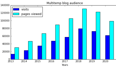
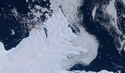
In English

2021, a festive year at CESBIO ?

=> As almost everywhere, 2020 has been a gloomy year at CESBIO ! Even if CESBIO has been relatively spared by the disease, with a low number of mild cases so far, a few of our colleagues lost relatives and we send them our warmest thoughts ! The situation is probably the same for the […]

Copernicus

Free and open data: fine, but who pays for the processing?

In the previous post, Olivier advocated for the open data policy in remote sensing. Although Oliver is facing some actual resistance because the Sentinel-HR mission would step on the toes of industrial champions, my feeling is that there is now a large consensus on this issue. The economic and social benefit of the open data […]

Copernicus

Free and open data pays off

As for most users of Copernicus or LANDSAT data I guess, the advantages of free and open remote sensing data are so clear that it’s hard to imagine they could be challenged. However, in the framework of Sentinel-HR phase 0, we prepared arguments in case our requirement for free and open data is questioned. Table […]

In English

How to make a mosaic of Theia snow products in three command lines

Assuming that you have downloaded from Theia and unzipped several products in the same directory. Assuming that you have a Linux OS with GNU Parallel, GDAL and OTB command line utilities installed..      Then, in your terminal, type: # Get the color table wget https://gitlab.orfeo-toolbox.org/remote_modules/let-it-snow/-/raw/75-lis-color-table-for-otb-not-updated-after-changed-nodata/hpc/LIS_SEB_style_OTB.txt # reproject all SNW raster products to a common […]

En Français

Préparation de la mission TRISHNA dans les Pyrénées

Dans le cadre de la préparation de la mission thermique TRISHNA (CNES/ISRO), le Cesbio met en place un dispositif expérimental de suivi de la température de surface dans les Pyrénées. L’objectif principal est de mieux connaitre la plus-value de la température de surface pour caractériser les propriétés internes du manteau neigeux. En particulier, l’assimilation des […]

In English

Evaluating ERA5 wind direction with Copahue Volcano plume

Copahue is an active volcano in the Andes on the Chile-Argentina border. It erupted in 2016 and a plume of smoke was visible in many Sentinel-2 images during that period. Looking at these pictures I thought it would be fun to use that plume as a giant anemometer to evaluate climate model data. I extracted […]

Le banc d'Arguin et la dune du Pilat vus d'avion

En Français

Le banc d’Arguin vu par satellite depuis 1984

L’archive Landsat est une mine d’or pour regarder notre planète changer. Google et Amazon ne s’y sont pas trompés puisque leur serveurs ont avalé l’ensemble des images pour permettre aux scientifiques et autres curieux d’y accéder plus facilement. Par exemple, cette application basée sur Google Earth Engine par Qiusheng Wu permet de générer une animation […]

En Français

Copernicus Land – High-resolution Snow and Ice Monitoring: processing campaign status

  Snow and ice products are now available at high resolution (20×20 m) for all Europe in near-real time. However, Magellium is also processing the Sentinel-2 archive since September 2016. About 70% of Sentinel-2 observations have already been processed and 50 % are already published. This huge computation is being done on the CNES HPC […]

In English

Stealth snow near Albuquerque, New Mexico

« Give me a hundred tries, I’ll never be able to spell it. » Jimmy McGill I haven’t seen the « Breaking Bad » series but I’m a huge fan of « Better Call Saul ». Both series take place in Albuquerque, New Mexico. With its dry, sunny weather, Albuquerque is the perfect place for a modern-day Western. Vince Gilligan, the […]