
An overview of irrigation evolution in Central Asia with Landsat
In Central Asia former soviet republics, pre-independence water allocation and irrigation system infrastructure were well maintained and operated with massive funding from the central government of the Former Soviet Union. Since independence, the situation has changed dramatically politically, institutionally and technically. Political transition from a planned to a market economy has introduced ‘new’ concepts such as land tenure, water rights and different kinds of ownership. The institutional changes are described as a transition from former state collective farms – kholkhoz and sovkhoz – to smaller private farms. (FAO report #39)The Kyrgyz Republic is a landlocked country in Central Asia with a total area of 198 500 km2 and about 6 million inhabitants. It became independent from the Soviet Union in August 1991. Most of the land formerly controlled by the 195 kolkhoz (collective farms) and 275 sovkhoz (state farms) has been distributed to their employees and dependants in the form of certificates extending 99 years of land-use rights. 1 million hectares of fields are irrigated : almost all irrigation uses surface water, and only 4.4% of the water comes from groundwater (FAO report #39). FAO Aquastat surveys show that the Kirghiz consumption of water for agriculture has dropped from 9486Mm3 in 1994 to 7447 Mm3 in 2006 (-21%), but they also say that « These data should be used with caution, since the reason for this is not clear. It may be the result of computation methods, data quality, changed cropping pattern or improved irrigation techniques. » We (1) have been looking at the evolution of an irrigated scheme on the southern bank of the Issyk Kul lake. The water which is coming from Karak Batak glacier melt, snow melt, and other rain runoff flows along the Chon Kyzyl Suu river which is then diverted to the Bolshoi and Polanski canals. The statistics of water diversion (2) to those two canals show a huge drop between 1996 and 2004, followed by a flat evolution until 2012. The volume diverted in the 2000s is half the volume of the 1990s, so we would expect that the cropped area of the 90’s was much bigger than in the 2010’s.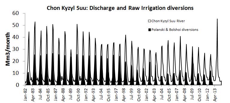
Now, let’s dive into the Landsat archive. An almost yearly time series of images Landsat 5, 7, 8 taken at the end of august when crops are the most developed is shown below. As climate is semi-arid, what is green in the polygon is very probably irrigated. At the beginning of the time series, we can see big homogeneous cropped areas typical of Kolkhozes. In 1996, the dismemberment begins and seems to reach its current state in between 2002 and 2006. The recent images of Landsat8 in 2015 and 2016 show that the irrigated area is intensively cropped, but also with a lot of small fallow plots.It is actually difficult to say if the 1990 image is more cropped than the 2016 image. So in the next issue, we’ll try to extract some matter from this data. (1) This study is conducted in the mark of the Hybiss project (HSM, LEGOS, CESBIO, CNRM and the Institute of Water Problem and Hydropower of Kyrgyztan) which is aiming to develop methodologies to estimate water balance of an endoreic mountain lake, using different satellite techniques, coupled to a watershed and lake model. Water level , snow cover, Evapo-Transpiration, open water evaporation and finally land surface cover are all inferred from multi-sensor remote sensing data.(2) The data was kindly made available to the project by the Jety Oguz water district.

