New version of fully automatic land cover map of France for 2014 from LANDSAT8

=> Over the last months, we worked a lot on our method for Land Cover map production. Three main topics (1) were studied with Arthur Vincent and David Morin at CESBIO :

  1. porting and validating the iota2 processor on the CNES High Performance Computing facilities (HPC);
  2. enhancing the method for reference data preparation. Reference data are used both for training and validation;
  3. developing a stratification method which allows to train and apply classifiers per eco-climatic area, for instance.

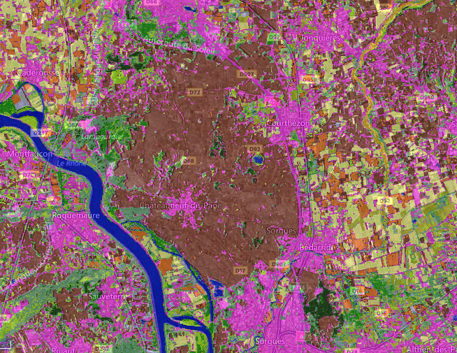
Using all these new features, we produced a lot (really a lot!) of maps for the continental France. We just released the 4 following examples, produced using all the available LANDSAT8 data in 2014 :

  • regarding reference data :
    1. including 4 classes of artificial surfaces : continuous urban , dicontinuous urban, road surfaces, and commercial and industrial areas (2);
    2. only one artificial class that gathers the 4 above (3);
  • regarding the stratification method :
    1. using eco-climatic areas (4);
    2. without stratification, but using a fusion of several classifiers trained over different sets of tiles.
The pink urban spot, in the center of brown zone, is the village of Chateauneuf du Pape which is famous for its wine, and the brown color is the vineyard class. Validated !

Arthur set up a convenient user interface for displaying and comparing the maps. You can see them here. The top left icon allows you to select the displayed maps. On the left, under the buttons which set the zoom level, you can select 2 of the maps and display their F-score statistics5. You can also display the older  version published earlier this year, whose quality is lower. If the Overall accuracy is higher than the new ones, it is only because at that time we used a lot of water surfaces in the validation, which are easy to detect. But that version classified mineral surfaces and orchards as urban areas. Improving the reference data improved the results. To compare the maps, you can have a look at the F-Score values : the eco-climatic stratification deeply enhances the average values and narrows the confidence intervals. To retrieve the full resolution files (which are really big), you can use the following links :

 Please send us feedback, it will be useful to further enhance our methods.

Notes:

1 Many other tasks were implemented such as preparing Sentinel-2 data ingestion.
2 These 4 classes come from Corine Land Cover 2012, after a cleaning of polygons using a method developped by Marcela Arias and David Morin, described in these slides (from slide 33).
3 Traning is always performed with the 4 urban classes, which are gathered afterwards. It enhances the map accuracy even if some thematic information is lost. LANDSAT8 30 m resolution does not allow for a very accurate classification of these surfaces.
4 We used the one published by Joly et al.
5 This metric combines omission and commission errors.


Plus d'actualités

BIOMASS, the third launched satellite mission designed at CESBIO !

After SMOS in 2009, and VENµS in 2017, the CESBIO Laboratory is very proud to see its third proposed mission, Biomass, reach orbit. As always, it has been a long journey from the idea, at the beginning of the century, to the selection in 2013 as the seventh Earth Explorer Mission by ESA, to the […]

Satellite Stereoscopy for Water Resource Monitoring?

=> In arid or semi-arid regions, where irrigation is widespread, monitoring agricultural water resources is essential to anticipate shortages. These resources may come from large dams, small reservoirs, or groundwater aquifers. This is the case in the state of Telangana, in South India, where numerous large dams (shown in cyan blue in the figure below) […]

La stéréoscopie par satellite pour le suivi des ressources en eau ?

=> Dans les régions arides ou semi-arides, où l’irrigation est généralisée, le suivi de la ressource en eau agricole est primordial pour anticiper les pénuries. Cette ressource peut-être l’eau de grands barrages, de petits réservoirs ou provenant de l’aquifère. C’est le cas de l’état du Télangana, en Inde du Sud, où de nombreux grands barrages […]

Rechercher