GDRI/IRN Sud Space4Sust
An International Research network of remote sensing experts for Environmental Science
Earth Observation for better understanding Earth
Remote sensing (RS) techniques from space have been increasingly used since 40 years to support studies in environmental sciences, which led to major scientific discoveries on earth system dynamics and trajectories. This is especially true over continental areas for which a thorough analysis of the processes linked to an acceleration of global changes is required [1]–[3]. Earth Observation data (EO) were harnessed to monitor in particular ice sheet losses, coastal and continental water evolution, deforestation, natural and agricultural area productivity and stress factors as well as urban fast expansion and densification.
Global Satellite data, an international shared media
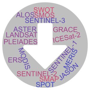
Yet, EO data and RS based modeling are taking an increasing part in environmental research since the last decade with the increasing availability of both long term EO observations (Landsat, SPOT, MODIS, MERIS, ASTER, ALOS, ERS) and new satellite missions launched with new type of sensors (SMOS, SMAP, GRACE, ICESat-2) or improved spatio-temporal resolutions of usual sensors (Sentinel-1&2), available worldwide for free. Local Essential Environmental Variables can be now monitored from space at a regional scale to improve our ability to perform diagnostics and to provide quantitative estimates of the climate and human induced changes using FAIR data (Findable, accessible, interoperable and reusable) and open source software with inter-disciplinary knowledge co-constructed with and for local partners.
Foster cooperation to tackle emerging environmental issues
In that context, the GDRI/IRN Space4Sust strives to support an international network of RS specialists that use EO data to retrieve their respective EEVs over continental ecosystems. It is primarily based on a long history of collaboration and a strong network in the Mediterranean area, India and Vietnam on the topic of multi-temporal and multi-wavelength remote sensing observations for the monitoring of water resources, storages and uses, crop growth and stressors, fast deforestation and afforestation, and forest biomass estimates, but also early warning systems and/or disaster response.
[1] T. Lopez, A. Al Bitar, S. Biancamaria, A. Güntner, et A. Jäggi, « On the Use of Satellite Remote Sensing to Detect Floods and Droughts at Large Scales », Surv. Geophys., vol. 41, no 6, p. 1461‑1487, nov. 2020, doi: 10.1007/s10712-020-09618-0.
[2] M. F. McCabe et al., « The future of Earth observation in hydrology », Hydrol. Earth Syst. Sci., vol. 21, no 7, p. 3879‑3914, juill. 2017, doi: 10.5194/hess-21-3879-2017.
[3] E. Martin et al., « On the Use of Hydrological Models and Satellite Data to Study the Water Budget of River Basins Affected by Human Activities: Examples from the Garonne Basin of France », Surv. Geophys., vol. 37, no 2, p. 223‑247, mars 2016, doi: 10.1007/s10712-016-9366-2.